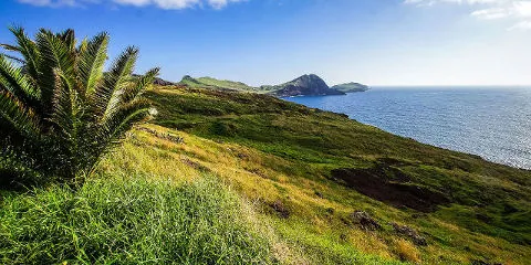
São Lourenço, located at the eastern end of the island, is one of Madeira's most popular spots. It contrasts with the rest of the island, rather green and humid, with its rocky soil and rugged cliffs. Its exceptional coastline is an invitation to discover a preserved nature through the small marked path, called vereda da ponta de São Lourenço.
The Point of Saint Laurent
If we want to Frenchify its name completely, we will speak of Pointe de Saint Laurent (but we almost never find this term on the internet). The place is almost devoid of vegetation, even if the flora and fauna are not left behind, with notably numerous lizards and sea birds, as well as rare and endemic plants. This lack of vegetation is mainly due to the very present wind and the much drier climate than the rest of the island. After a short ascent, the small islets are the highlight: Isla da Cevada and Isla do Farol with its lighthouse.
Discover the peninsula on foot with the PR8 vereda
After passing the small village of Caniçal (30 km from Funchal), you can leave your car in the car park to start this short hike - PR8 - without any real technical difficulty. The path is quite well marked and safe and you will be surprised as you walk to discover some of the most beautiful views of the ocean, with the jagged volcanic coast.
You will quickly discover the magnificent Abra Bay, and why not stop for a moment to recharge your batteries on the small beach of São Lourenço? As the route progresses, we will be delighted by the magnificent views offered by the cliffs of the Vista Point and Castello Point.
Hiking information
Vereda de la Ponta de São Lourenço - PR8
Type de parcours : boucle
Altitude Max : 500 m
Difficulty : facile
6.39 km
3 h
+400 m
The GPX course is provided for information only and without guarantee.

The peninsula follows, culminating in the tip of the island and the Point of Furado, whose summit rises to 120 metres and which will allow you to discover the islet of Cevada and the islet of Farol, home to Madeira's oldest lighthouse, which is now fully maintained and modern. Before returning you can stop for a while at the Sardinha rest area, there is a possibility to have a small snack at the casa do sardinha, and even go down to the small beach of cais do sardinha for a while.
Some tips for having a good experience :
One of the most beautiful spots on Madeira Island, unfortunately, is also very crowded. São Lourenço is a must-see, so be smart about your hikes: it's better to leave a little earlier in the morning to avoid the influx of tourists. And don't forget to be properly equipped, especially because of the wind.
To do also near the peninsula:
It is possible to continue hiking by combining a short walk with a view of Caniçal and the beautiful scenery of Punta do Rosto. Not far from there, the town of Machico awaits you, with the Pico do Facho and the Levada do Caniçal trail.
 Départ et arrivée de la randonnée.
 Montagne
 Village
 Randonnées
 Musées et visites
 Levada
 Eglises et Chapelles
 Point de Vue
 Plage
Plage Phare
Phare Point non identifié
Très jolie randonnée faites fin juillet 23 avec des enfants. Pas de difficulté particuliere sauf l'absence d'ombre et la queue pour la pause pipi au relais de la sardhina. Il y a du monde certes mais franchement on s'attendait à pire...il ne faut pas arriver après 10h si vous voulez trouver une place de parking.