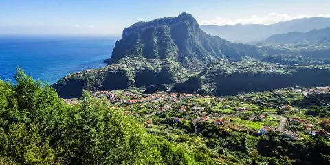
Penha de Águia, known as the Eagle Rock in French, is a green mountain culminating at about 550 metres above sea level, in the north-east of Madeira, between the small municipalities of Faial and Porto da Cruz. This volcanic mound was formed by the emission of vast quantities of lava 5.8 million years ago. To discover this large rock, there are several viewpoints on the island. It is also possible to hike along this large rock to the delight of walkers, however it is only about 320m up. It is one of the most beautiful spots on the island.
The most beautiful viewpoints to admire Penha de Águia :

.jpg by Alberto-g-rovi is licensed with CC BY 3.0. To view a copy of this lic")
Miradouro da Portela: coming from Funchal or Machico, this is the most incredible viewpoint to discover the city of Porto da Cruz and the Eagle Rock to its left. There is even a bar here to stop for a while.
From the fortress of Faïal. The bell tower of the church stands out from the landscape to make way for the big rock.
The Miradouro de Nossa Senhora: to the east of Faïal, a distant view of the village, with Penha de Águia in the background.
Miradouro do Curtado: a little further and higher than the previous viewpoint, the place offers an even more panoramic view. It's a great place to be!
Miradouro do Guindaste (Crane viewpoint): the coastline that juts out into the ocean from Faïal allows you to see the entire steep cliff of the mountain.
The Vereda da Penha de Águia:
The hike is not very long but a bit demanding. The route I propose starts from Porto da Cruz and goes to the centre of Faïal. The route follows Penha de Águia from the interior of the island. It is possible to do it in the opposite direction and as a loop (see map below for details of the route).
After leaving the village of Porto da Cruz, we climb (quite steeply) the Eagle Rock until we reach a viewpoint at about 320 m altitude which offers us a superb landscape over the village and the cultivated fields. In the distance, the point of São Lourenço comes into view. As we continue along the route, we gradually approach Faïal. The panorama that opens up is nothing less than the interior of the island and Madeira's picos, including Pico Ruivo: it's breathtaking. The landscapes are breathtaking, and what can we say about the surrounding nature with many flowers, many mimosas in fact.
Count approximately 8 kilometres to carry out the course and to reach the centre of the second village: Faïal. I added it in the track but it is perhaps not necessary to go until the centre of the village, of which one observes the bell-tower of the church from far. Indeed, it climbs again. A slight difference in altitude of about 150 m, which can make your legs ache. It may be sensible to retrace your steps and visit Faïal later by car. Some of the views from here are simply superb, especially of the coast and the Atlantic Ocean. Generally speaking, the climb up the rock is worthwhile and may require some effort, even if the difference in altitude is not impressive.
 Point de départ
  Point d'arrivée de la randonnée.
 Montagne
 Village
 Ville
Ville Piscine naturelle
 Musées et visites
 Eglises et Chapelles
 Point de Vue
 Cascades
 Plage
Plage Maisons de Santana
 Point non identifié
Bonjour,
Nous avons effectué une partie de cette randonnée en date du 02 septembre dans le sens Faial -> Porto Da Cruz. La montée vers le rocher est exigeante et le chemin assez technique par endroit. Les courbes de niveaux ne sont pas indiquées correctement sur certaine cartes (notamment celle utilisée par Strava). Ainsi, le profil de dénivelé est beaucoup plus important que prévu. Ce site mentionne une altitude max de 333m, nous avons fait demi-tour à environ 390m. En regardant les cartes après coup je vois que nous étions encore loin du rocher. Attention ! Le dénivelé de cette randonnée est considérablement plus élevé que celui mentionné.