Pico Ruivo: the highest peak on Madeira Island. It reaches 1861 metres and is closely followed by its neighbours, Pico di Arieiro and Pico das Torres, which reach 1818 and 1851 metres respectively.
Climbing from the Achada do Teixeira plateau
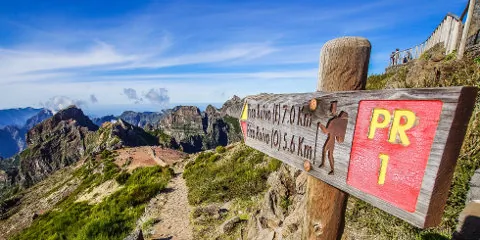
This mountain is very easily accessible by a hiking trail that starts on the Achada do Teixeira plateau, which is situated at an altitude of about 1500 metres and is about 50 minutes from Funchal. You can leave your car at the car park in the morning and discover the highest point of the island. With such a high starting point, the hike up Pico Ruivo is not the most difficult in terms of altitude difference: less than 300 metres of positive difference in altitude and a total route of less than 3 kilometres.
As with all hikes in Madeira, make sure you are at least equipped because of the wind and the sometimes capricious weather: it is not uncommon to start the hike in clouds and mist. The beginning of the climb offers views of the pico Das Torres and di Arieiro. A big surprise may await you at the top as you can find yourself above the clouds, with a 360° panoramic view of the island and the ocean.
The path is again well signposted and safe, on a cliff side, but with incredible landscapes of the heart of Madeira Island and a breathtaking panorama. Not to be missed! This is where we see that Madeira is truly multi-faceted, after discovering the villages and the seaside, hiking along the levadas, here we are in a mountainous atmosphere!
The classic: the 3 highest peaks
This is not the only possible route, there is also another hiking trail that leads to the Pico: the Pico do Arieiro Pico Ruivo crossing. The hike is much more demanding, however, and the path takes you through tunnels and numerous stairs several times. Once again, grandiose landscapes on the crests and on the ocean, but it must be deserved: a lot of difference in altitude (+/- 1000 meters) for a distance of 10 km.
The longest from the west of the island
Finally, there is a third route, from the west of the island, starting from Bocca da Encumeada. You will clearly have to start in the morning because it is very difficult and demanding: a little more than 20 km for a duration of 10 to 11 hours of walking, hard! If you are not an experienced hiker, you should rather choose one of the first two routes, which are more accessible.
 Point de départ
  Point d'arrivée de la randonnée.
 Montagne
 Village
 Randonnées
 Levada
 Eglises et Chapelles
 Point de Vue
 Cascades
 Forêt primaire
 Tunnel
 Point non identifié
Belle randonnée, mais expérience gâchée a cause du nombre incroyable de gens qui apportent leur drone notamment au sommet … c est une véritable plaie pour la faune locale et les randonneurs.